
Lake Mitchell Water Quality
Lake Mitchell Water Quality - Drain Commissioner's Report
By Mike Solomon
There is no question that Lake Mitchell and Cadillac are of vital importance to our community. Understanding the natural systems and events that influence the lake is an essential part of our efforts to maintain the health of the lake and it helps us to recognize the why behind the changes we see in the lake during any one year.
The following table provides an overview of lake conditions and precipitation levels for 2023. Included in the table are end of the month lake levels, monthly historic lake levels, monthly precipitation, mean precipitation for the month and percentile occurrence for the monthly lake level. Lake levels are in feet and precipitation is in inches. The percentile occurrence provides a comparison of the 2023 levels with levels recorded over the past 48 years. For example, the January-2023 lake level of 1289.61 feet, exceeded 72.3% of the lake levels recorded for the month of January over that historic time span. The mean precipitation data point provides the average amount of precipitation that we see for any given month, based on the past 33 years of data, which allows us to compare a historic average with the amount received in 2023.
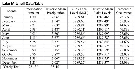
There is a lot of information that can be gleaned from this data. Lake levels came back to the spring target level of 1290.00 feet - Mean Sea Level (MSL) set by Court Order (# 585 September 1967) by the end of April. This has occurred every year since 1991.
However, our annual precipitation for 2023 was only 28.13 inches compared to the mean annual average of 35.45 inches. So, we experienced a 21% reduction in the total amount of precipitation for the year, when compared to the long-term average amount, which significantly impacted summer lake levels.
The table also illustrates that from January through April the levels were from 44.6 to 72.3 of the percentile occurrence. That is, the lake levels exceeded or nearly exceeded the mean monthly values for that period. Low precipitation in May and June (a total of 2.06 inches compared to the 7.27 inches expected) resulted in lake levels falling to 27 percentile occurrence levels. July and August were wetter than normal totaling 9.28 inches compared to the expected value of 7.31 inches, and the percentile occurrence levels responded to 44.6% and 40.4% respectively. Low rainfall in September, November, and December, once again resulted in lake levels falling during those time frames.
There is no doubt that monthly precipitation is the driving force in what the lake level will be. We are fortunate to have large wetlands that feed the lake and three streams (Mitchell Creek, Brandybrook Creek, and Gytja Creek) that provide steady supplies of water to Lake Mitchell. Other lakes in Wexford County are not as fortunate. Stoneledge and Meauwataka lakes are down 3 to 4 feet from recent high levels and Pleasant Lake has dropped approximately 2 feet.
The Court Order, which serves as the basis for the management of the Clam River Dam outlet from Lake Cadillac, requires the dam to be opened in late fall to provide storage capacity for expected precipitation levels in the form of snowfall and spring rains. The dam remains open until the lakes fall back to the 1290.00 feet MSL target level in the spring. At that point, the dam is closed to preserve as much water as possible for the summer recreation season, except for a minimum flow discharge opening that preserves the water quality and fish habitat quality in the Clam River. Even after the dam is closed for the summer season, as we have seen, the lakes are very dependent upon monthly rainfall because of the amount of water being lost due to normal evaporation.
(Thanks to Jack Linn for continued statistical analysis)
Spring 2023
Drain Commissioner’s Corner
By Mike Solomon, Wexford County Drain Commissioner
Current status of Lake Levels
Many of you have heard of or seen the Court Order 585 (1967) by Judge William Peterson. It basically states the following:
1. That the annual maximum level is set at 1290.0 feet
2. That a minimum winter level is established at 1288.9 feet
3. That a summer minimum level is established at 1289.7 feet
Along with the basic court order Judge Peterson gave much additional information about lake levels. Most of this information came from two studies done by the Michigan Department of Conservation in 1955 and 1967. These were the basis for the determination of the legal lake levels.
I think the most important part of the Opinion of the Court is the fact that the Judge ordered the summer level of the lakes to commence at 1289.7 feet (see above) instead of the Department of Conservation’s recommendation of 1289.4 feet. This 0.3 feet (3.6 inches) makes an incredible difference in summer boating use and would be even more critical for late season fishing.
Drain Commissioners have recorded lake levels on Lake Cadillac and Mitchell on a monthly basis since 1975. These data show the lake levels are usually within the levels cited in the Opinion of the Court, though an all time new high was reached on June 18, 2008 with a level 1291.5 feet. This was the result of 11.83 inches of rainfall for the month.
Lake levels are a reflection of the combination of precipitation, evaporation and dam operation. We have had 5 of the last 6 years with above normal precipitation. Warmer summer temperatures and high winds result in more evaporation. Looking at the recent data it appears it is more difficult to reduce lake levels both in the summer and to try to obtain the winter water level. This could be a result of several factors. With the conversion of small summer homes to large homes with patios and large driveways and garages has resulted in much more impervious surface. This increases rapid runoff that often times drains directly into the lake. We have over 4,000 acres of surface water and a large watershed (28,593 for Lake Mitchell alone) that all outlet down a 25 foot channel of the Clam River. Additionally there are over 2 million gallons per day in groundwater cleanup being discharged to the Clam River that were not present at the time of the Court Order. There are also obstructions in the river that may impede flow.
It is an interesting challenge to operate the lakes within the Court Ordered levels and to receive input from lake users and riparian owners that have their own thoughts on lake levels.
I have had the lake level data from the last 48 years summarized and statistically analyzed. Using these spreadsheets it is easier to make sound decisions based on scientific records to keep the lakes within the Court Ordered levels that have been established.
I appreciate the help that Jack Linn has provided with assembling and analyzing lake level data and providing a sounding board and recommendations to help with lake level decisions.
Spring 2022
Drain Commissioner’s Corner
By Mike Solomon, Wexford County Drain Commissioner
Many of you have heard of or seen the Court Order 585 (1967) by Judge William Peterson. It basically states the following:
1. That the annual maximum level is set at 1290.0 feet
2. That a minimum winter level is established at 1288.9 feet
3. That a summer minimum level is established at 1289.7 feet
Along with the basic court order Judge Peterson gave much additional information about lake levels. Most of this information came from two studies done by the Michigan Department of Conservation in 1955 and 1967. These were the basis for the determination of the legal lake levels and I feel are important to understanding the Order and knowing the background information of “why?” the levels were set as they were. The following will be direct quotes from Judge Peterson’s write up entitled “Opinion of the Court”.
The Judge cites “…the engineering studies disclose that there are improvements adjoining the lakes which have annually suffered from flooding or the effects of the annual spring high. Some properties have been developed which are lower than the average of any year. The owners of such property have made their improvements at their peril with reference to an existing condition of the lakes and cannot now justifiably claim that the protection of their property warrants a reduction in levels which are disadvantageous to other owners and the public…”.
Judge Peterson discusses the spring runoff that raises lake levels and evaporation exceeding summer rainfall that causes lake level reductions. He states “The average summer loss has been approximately 1 foot; in the wettest summer it has been as low as 0.4 of a foot. In the driest summer it has been as much as 1.6 feet.”
“Over the years of recorded lake level experience, the fluctuations from an annual high to an annual low has been as much as 3 feet. In any given year, the fluctuation has never been less than 0.9 feet and as much as 2.0 feet. It is the purpose of the proceedings under the statue to attempt to stabilize the lakes so far as possible, taking into consideration the natural phenomena noted, and to reduce the extremes of high and low water each year.”
The Judge cites: “The following facts are pertinent and worthy of note:
1. The annual high level of the lake has generally been over 1290.0 feet above mean sea level and in at least one year has come close to 1291. Continued maintenance of a level of 1290, or higher will have adverse effect on septic tanks surrounding the lake, basements and other improvements, and increases erosion of shoreline by ice or wave action.
2. “The annual low has generally been below 1289. feet below sea level. Only four times since 1942 has the lake failed to fall to that level and once it has fallen as low as 1288.0 (1955). A low is desirable as the winter approaches from the standpoint of minimizing of ice erosion and as a means of preparing for spring runoff which will follow. A low level in the spring or early summer, however, leaves the lake vulnerable to further reduction by the summer evaporation and a continued low has an adverse effect on the lake as such, not only from the standpoint of boating and recreational use and appearance, but also because of the increased marine growth.”
Lake levels are a reflection of the combination of precipitation, evaporation and dam operation. We have had 5 of the last 6 years with above normal precipitation. Warmer summer temperatures and high winds result in more evaporation. With the conversion of small summer homes to large homes with patios and large driveways and garages has resulted in much more impervious surface. This increases rapid runoff that often times drains directly into the lake. We have over 4,000 acres of surface water and a large watershed (28,593 for Lake Mitchell alone) that all outlet down a 25 foot channel of the Clam River.
It is an interesting challenge to operate the lakes within the Court Ordered levels and to receive the input from lake users and riparian owners that have their own thoughts on lake levels. Occasionally I have had people comment that the lake is too high and others say it is too low on the same day. Some users are interested in having the Court Order modified. I do not think that is a good idea because I think Judge Peterson’s interpretation of the findings are accurate and his Opinion of the Court explains his reasoning very concisely. Furthermore, we have no indication where further studies would lead us and we would need to be prepared to implement the results.
Lake Levels and Dam Operation -2021 Report
As we enter the summer boating season for 2021, we find that our levels on Lake Mitchell and Lake Cadillac are relatively low when compared to what we normally expect in the spring after snow melt. Why are lake levels so low right now and what might it mean for the coming summer? Not surprisingly, the answer to that question is largely tied to the amount of rain and snow the area received in 2020.
During 2020, we had 34.01 inches of total precipitation, compared to our annual average over the past 30-years of 35.45 inches. So, our precipitation amount in 2020 was about 1.5 inches below the average and then we received very low snow amounts for the first three months of 2021. Ten inches of snow is roughly equivalent to one inch of rain. The question has been raised as to whether the lake levels can be raised by reducing or even eliminating flow into the Clam River at the outlet dam near the Cadillac Schools complex.
Management of the Clam River dam is a duty of the Wexford County Drain Commissioner and the procedures and target winter and summer lake levels are tied to past Circuit Court decisions. The dam was fully opened on October 24, 2020. The dam has historically been left open in the winter with the objective of reaching a lake level 1288.90 feet. That procedure established on the basis of the court decision is intended to provide storage for the expected snow melt and spring rains that we see most years.
Despite opening the dam’s gates earlier in the fall than the Opinion of the Court suggests, there has been only one year in the past 30 years that the recommended winter target lake level has been reached. Precipitation from December 2020 through March 2021 was only 4.45 inches compared to the long term expected amount for those 4 months of 7.73 inches. Recognizing the moisture deficit was going to lead to lower lake levels, early action was taken to close the dam gates on March 29, 2021, which is fully two months before they have normally been closed.
Even when the dam outlet gates are closed, there is an 8 inch by 8-inch square hole in the concrete structure of the dam that provides a continuous flow to the Clam River. The discharge through this hole varies by the height of the lake levels or a measure of “head” above the hole. The need for a continuous flow into the Clam River was cited in the Wexford County Board of Public Works minutes and correspondence concerning the dam’s original design. Both the State of Michigan Department of Environment, Great Lakes and Energy (EGLE) and the Fisheries Division of the Department of Natural Resources support he continuous flow into the Clam River. Severely restricting or periodically drying up that flow would have adverse consequence on fish and aquatic habitat in the Clam River.
Any changes to streamflow fall under Part 301 of the Michigan Natural Resource and Environmental Protection Act (1994). Under Part 301, a person shall not structurally interfere with the natural flow of an inland lake or stream, or create, enlarge or diminish an inland lake or stream. Any proposal to change the Clam River flow would require a permit that would have to be obtained through EGLE. Such a proposal would likely be opposed by the MDNR Fisheries Division and would involve a potentially lengthy and expensive process that may ultimately fail. A change of the procedure would have a variety of effects on the watershed of Lake Mitchell and Lake Cadillac, all of which would need to be addressed. It is for similar reasons that Circuit Court became involved in setting target lake levels decades ago.
It has been fairly-well established that weather patterns have been changing during the past 20 to 30 years. More rainfall, less severe winters and associated snowfall amounts, and larger and more frequent storm events have become the norm. For example, Mason County to our west set a new 24-hour rain event of over 13 inches in 2019, the highest ever recorded in Michigan. What have historically been classified as 50-year and 100-year storm events seem to be occurring with much greater frequency and have lost a certain amount of meaning. That being said, we still will have dry summers, such as occurred in 2018, resulting in lower-than-normal water levels that did not rebound until fall. The winter of 2020-2021 was again abnormally dry by historic measure. It appears that we can expect lake levels to vary through a somewhat wider range than they did 40 or 50-years ago; and attempting to alter established lake management procedures on a yearly basis is not a practical solution. We are still lucky to have two large lakes with substantial inflow and springs that keep water levels more stable than are seen in many other area lakes such as Pleasant, Stone Ledge and Meauwataka.
As of April 7, 2021, the lakes are about 2.25 inches below the Court Established target summer level. This does not suggest that we should already write-off the 2021 boating season, there is still hope. The normal average rainfall in April is 3.54 inches, May normally brings 3.62 inches and June 3.69 inches. This is a total three-month average rainfall of 10.85 inches, and it’s the highest expected rainfall for any consecutive three-month period out of the year. Expected summer rainfall has July at 3.52 inches, August at 3.57 inches, and September at 3.16 inches, based on 30 years of data. Hopefully, our average spring and summer rainfalls will come and help to raise our water levels.
We have a wonderful privilege to live on or near these lakes. Let’s continue to enjoy and protect them.
Drain Commissioner's Report
LOOKING BACK AT LAKE LEVELS IN 2016
Long term rainfall averages for the Cadillac area had been around 32 inches annually throughout the 1950’s to the 1980’s. More recent annual precipitation has been much more erratic. The 10-year period from January 2007 through December 2016 had an average of 35.73inches. This is similar to the average for 1991 to 2016 of 35.19 inches. This increase is a substantial amount of additional water on the watershed and has had a tremendous impact on the lake levels of Lakes Cadillac and Mitchell. The average precipitation for 2016 was 32.73 inches with high amounts in May (4.62 inches) and July (5.11 inches).
Last year (2016) we had high lake levels during winter and spring. It did not drop to 1289.70 feet which is the summer level until July 1st. Much of the high spring lake levels were driven by melt of the snow pact with high rainfall in March. The combination of high or intense rainfall on an existing snow pact or saturated soils will almost always result in a large amount of runoff into the lakes and higher lake levels.
So what causes these increases in lake levels and fluctuations? Changes in precipitation patterns would appear to significantly contribute to these changes. A US Department of Agriculture publication cites a “180 percent increase in rainstorms of 3 inches or more occurred between 1960 and 2011. The northern Lower Peninsula in particular had a larger increase in heavy rainfall events than surrounding states with 50 to 100 percent increases in the frequency of large precipitation events from 1931 to 1996.” Additionally, there has been a large increase in impermeable surfaces around the lake in the last 50 years. Small fishing cottages have become 2000 square foot year round homes with 2 or 3 stall garages and extensive driveways causing a significant increase in runoff to the lake. Wide lake level fluctuations can be expected in future years.
The dam on the Clam River has been open since late fall and still the level of the lake has risen over the winter until it is above the spring recommended levels of 1290.00 feet (as of March 7, 2017). We still have ice out and most likely spring rains to look forward to.
Every year is significantly different as to temperatures, precipitation, snowmelt and the timing of precipitation. So who knows what 2017 will bring for lake levels. I know that the high lake levels desired by some are disliked and may cause damage to others. Likewise low lake levels cause concerns for many who are in coves or canals that were man-made and have undergone sedimentation in the more than 50 years since they were constructed. The current Circuit Court Order seems to be a good compromise for all concerned.
Drain Commissioner's report
Looking back at lake levels in 2014
by Mike Solomon
Long term rainfall averages for the Cadillac Area have been around 32 inches annually throughout the 1950’s to the 1980’s. More recent annual precipitation has been much more erratic. The 10-year period from January 2005 through December 2014 had an average of 36.22 inches and the last four (4) years average ending in December 2014 was 38.38 inches. This is a substantial amount of additional water on the watershed and has had a tremendous impact on the lake levels of Lakes Cadillac and Mitchell.
Last year (2014) we had very high lake levels for much of the year. The lake peaked at 1291.16 feet (MSL) on April 21, 2014. It did not drop to 1290.00 feet which is the spring level until July 21st and summer level of 1289.70 feet was not reached until August 12th. Much of the high lake levels were driven by melt of a relatively large snowpact with an exceptionally high rainfall of 6.60 inches in April. The combination of high or intense rainfall on an existing snowpact will almost always result in a large amount of runoff into the lakes and higher lake levels.
The high lake levels in April and May caused localized flooding. There was a lot of ponded water in yards and water accumulating in crawl spaces and some basements. Individual homeowners had some amount of damage and sump pumps ran almost continuously for some homeowners. Lake levels were excellent for boating throughout the summer but far exceeded the Court Ordered lake levels.
August, September and October were maintained at about normal summer lake levels. The dam was opened on October 10 to begin the drawdown to winter levels (1288.90 feet). Significant rainfall in November prevented obtaining that level and the dam has been left open from that time until now (the end of March).
Every year is significantly different as to temperatures, precipitation, snowmelt and the timing of precipitation. So who knows what 2015 will bring for lake levels. I know that the high lake levels desired by some are disliked and may cause damage to others. Likewise low lake levels cause concerns for many who are in coves or canals that were man-made and have undergone sedimentation in the more than 50 years since they were constructed. The current Circuit Court Order seems to be a good compromise for all concerned.
Water levels and dam rehabilitation 2013
Drain Commissioner’s Corner
Prepared by Mike Solomon
Dam Rehabilitation:
Mike Solomon, Wexford County Drain Commissioner, did a rehabilitation project on the Clam River Dam that controls the flow from Lakes
Cadillac and Mitchell. The dam was constructed in 1968 and has not had any significant maintenance done since that time. The dam is a two gate system that is used to control the lake levels as
established by the Circuit Court.
The project consisted of removing deteriorating concrete, replacing and moving the fencing off the wing walls, adding an additional control section to aid with low flow conditions and landscaping the area. We also sealed the concrete sections, and provided protective covers for the electrical components. The cost of the project is being split equally between Wexford County and the City of Cadillac.
In 2014 we will be replacing the seals around both gates reducing leakage and helping to maintain water levels in the lakes.
Lake Levels:
It may surprise some, but we received higher than normal precipitation in 2013. The total precipitation was 37.75 inches for 2013 compared to a
30 year average of 30.81 inches. Unfortunately it was highly variable. We received 5.4 inches of precipitation in the month of April along with a quick snowmelt. This resulted in the highest
water level recorded in any April since levels have been recorded beginning in 1975. We also received 6.24 inches of precipitation in November. That means 11.64 inches or 31% of our annual
precipitation occurred in those two months. At the other end of the spectrum, June, July and September were below normal months. The period of June through September totaled 10.21 inches of
precipitation which resulted in a lake level of 1289.39 feet MSL on November 1st. This is 0.31 feet below summer level but 0.49 feet above the winter level.
There is always a lot of conjecture and claims about low or high water levels. I have had more statistical analysis of our water levels done by working with Jack Linn who earned a living doing statistical analysis. He developed percentile tables of each month so I could compare the records with other monthly averages throughout our period of record. I heard claims that these were the lowest levels anyone had ever seen. When you look at the data the reading on August 1, 2013 exceeded 25 % of the readings on that date, September 1, 2013 was higher than 30 % of the readings on that date and October exceeded 25% of the readings on that date. So I think though we all would have preferred high water levels in 2013 they were far from the lowest recorded.
Lake Mitchell water level summary 2012 -- Water Quality Report
By Mike Solomon, Wexford County Drain Commissioner
2012 was officially the hottest year for the United States since records have been kept. Locally we started with early ice out as a result of 8 days in March that exceeded 80 degrees F. This gave the aquatic vegetation a head start and very vigorous early season growth. Eurasian watermilfoil was topped out by late May.
Lake water quality stayed about the same as it has for the last few years. Dissolved oxygen was adequate for warm water fish, conductivity is lower than many other lakes but showed some increase over the last few years, ph was circum neutral, and alkalinity (the measure of the pH buffering capacity of the lake or ability of a lake to resist change) is low indicating soft water. Total phosphorus has dropped some in the last few years but remain relatively high and are in the eutrophic range for the entire lake. Elevated levels of total phosphorus continue to enter from Brandy Brood and Mitchell Creek which are the two main tributaries. Sechhi transparency is a measure of water clarity and was up for the year. The average values have increased from 4.5 feet in 2009 to 6.2 feet in 2012
Lake levels on the whole were good for the year. A portion of August and all of September the lake was below the Court Ordered levels.
As most of you can remember we had a very dry August and September with only 1.90 inches of rain in August and 2.55 inches of rain in September. Even with these conditions the end of August saw the lake about 0.25 feet low or 3 inches and the end of September was 0.4 feet low or 4.8 inches. This is far better than the other lakes in Wexford County. This is a result of the dam and a large contributing area of wetlands in the watershed that slowly contribute water to the lake and buffer large differences in elevation.
Judge William Peterson issued Court Order 585 (1967) that controls lake levels on Lakes Cadillac and Mitchell. It basically states the following:
-
That the annual maximum level is set at 1290.0 feet
-
That a minimum winter level is established at 1288.9 feet
-
That a summer minimum level is established at 1289.7 feet
Along with the basic court order Judge Peterson gave much additional information about lake levels. Most of this information came from two studies done by the Michigan Department of Conservation in 1955 and 1967. These were the basis for the determination of the legal lake levels and I feel are important to understanding the Order and knowing the background information of “why?” the levels were set as they were. The following are direct quotes from Judge Peterson’s write up entitled “Opinion of the Court”.
The Judge cites “…the engineering studies disclose that there are improvements adjoining the lakes which have annually suffered from flooding or the effects of the annual spring high. Some properties have been developed which are lower than the average of any year. The owners of such property have made their improvements at their peril with reference to an existing condition of the lakes and cannot now justifiably claim that the protection of their property warrants a reduction in levels which are disadvantageous to other owners and the public…”.
Judge Peterson discusses the spring runoff that raises lake levels and evaporation exceeding summer rainfall that causes lake level reductions. He states “The average summer loss has been approximately 1 foot; in the wettest summer it has been as low as 0.4 of a foot. In the driest summer it has been as much as 1.6 feet.”
“Over the years of recorded lake level experience, the fluctuations from an annual high to an annual low has been as much as 3 feet. In any given year, the fluctuation has never been less than 0.9 feet and as much as 2.0 feet. It is the purpose of the proceedings under the statue to attempt to stabilize the lakes so far as possible, taking into consideration the natural phenomena noted, and to reduce the extremes of high and low water each year.”
The Judge cites: “The following facts are pertinent and worthy of note:
-
The annual high level of the lake has generally been over 1290.0 feet above mean sea level and in at least one year has come close to 1291. Continued maintenance of a level of 1290, or higher will have adverse effect on septic tanks surrounding the lake, basements and other improvements, and increases erosion of shoreline by ice or wave action.
-
“The annual low has generally been below 1289. feet below sea level. Only four times since 1942 has the lake failed to fall to that level and once it has fallen as low as 1288.0 (1955). A low is desirable as the winter approaches from the standpoint of minimizing of ice erosion and as a means of preparing for spring runoff which will follow. A low level in the spring or early summer, however, leaves the lake vulnerable to further reduction by the summer evaporation and a continued low has an adverse effect on the lake as such, not only from the standpoint of boating and recreational use and appearance, but also because of the increased marine growth.”
-
“Careful management over the past five years indicates that prudent management can generally reduce the level in the fall adequately to prepare for the accumulation of the spring runoff and maintain the lake at a level which will minimize the summer fluctuation. The dry season of the 1966 demonstrates that even careful controls cannot prevent loss up to a foot in summer evaporation, but the lake has generally been kept above 1289 minimum in every summer of the last five years. The effect of the controls of the past five years have, therefore, been not only to reduce the average annual fluctuation with particular reference to the high, but also to reduce the average summer fluctuation as well.” I note here the “past 5 years” appears to indicate the 5 years just preceding the Court Order of 1967.
Drain Commissioners have recorded lake levels on Lake Cadillac and Mitchell on a monthly basis since 1975. These data show the lake levels are usually within the levels cited in the Opinion of the Court, though an all time new high was reached on June 18, 2008 with a level 1291.5 feet. This was the result of 11.83 inches of rainfall for the month.
Lake levels are a reflection of the combination of precipitation, evaporation and dam operation. We have had 5 of the last 6 years with above normal precipitation. Warmer summer temperatures and high winds result in more evaporation. Looking at the recent data it appears it is more difficult to reduce lake levels both in the summer and to try to obtain the winter water level. This could be a result of several factors. With the conversion of small summer homes to large homes with patios and large driveways and garages has resulted in much more impervious surface. This increases rapid runoff that often times drains directly into the lake. We have over 4,000 acres of surface water and a large watershed (28,593 for Lake Mitchell alone) that all outlet down a 25 foot channel of the Clam River. Additionally there are over 2 million gallons per day in groundwater cleanup being discharged to the Clam River that were not present at the time of the Court Order.
Dam repair: This summer there will be some work done on the dam that controls the lake levels to bring it into compliance with comments provided during our 2012 dam inspection report. Concrete that has been damaged will be cut off and repaired. Additionally, security fencing on the east and west sides will be removed from the concrete wall and replaced just outside this area to prevent future damage to the concrete. An arm on the right bay will also be straightened or replaced. Finally channels will be placed in the minimum flow area so that there is some water level control in this area. It is anticipated that all work can be accomplished during normal summer lake levels.
Water Quality Report -- 2011
By Mike Solomon, Wexford County Drain Commissioner
More Than You Ever Wanted To Know About Lake Levels!
Many of you have heard of or seen the Court Order 585 (1967) by Judge William Peterson. It basically states the following:
1. That the annual maximum level is set at 1290.0 feet
2. That a minimum winter level is established at 1288.9 feet
3. That a summer minimum level is established at 1289.7 feet
Along with the basic court order Judge Peterson gave much additional information about lake levels. Most of this information came from two studies done by the Michigan Department of Conservation in 1955 and 1967. These were the basis for the determination of the legal lake levels and I feel are important to understanding the Order and knowing the background information of “why?” the levels were set as they were. The following will be direct quotes from Judge Peterson’s write up entitled “Opinion of the Court”.
The Judge cites “…the engineering studies disclose that there are improvements adjoining the lakes which have annually suffered from flooding or the effects of the annual spring high. Some properties have been developed which are lower than the average of any year. The owners of such property have made their improvements at their peril with reference to an existing condition of the lakes and cannot now justifiably claim that the protection of their property warrants a reduction in levels which are disadvantageous to other owners and the public…”.
Judge Peterson discusses the spring runoff that raises lake levels and evaporation exceeding summer rainfall that causes lake level reductions. He states “The average summer loss has been approximately 1 foot; in the wettest summer it has been as low as 0.4 of a foot. In the driest summer it has been as much as 1.6 feet.”
“Over the years of recorded lake level experience, the fluctuations from an annual high to an annual low has been as much as 3 feet. In any given year, the fluctuation has never been less than 0.9 feet and as much as 2.0 feet. It is the purpose of the proceedings under the statue to attempt to stabilize the lakes so far as possible, taking into consideration the natural phenomena noted, and to reduce the extremes of high and low water each year.”
The Judge cites: “The following facts are pertinent and worthy of note:
1. The annual high level of the lake has generally been over 1290.0 feet above mean sea level and in at least one year has come close to 1291. Continued maintenance of a level of 1290, or higher will have adverse effect on septic tanks surrounding the lake, basements and other improvements, and increases erosion of shoreline by ice or wave action.
2. “The annual low has generally been below 1289. feet below sea level. Only four times since 1942 has the lake failed to fall to that level and once it has fallen as low as 1288.0 (1955). A low is desirable as the winter approaches from the standpoint of minimizing of ice erosion and as a means of preparing for spring runoff which will follow. A low level in the spring or early summer, however, leaves the lake vulnerable to further reduction by the summer evaporation and a continued low has an adverse effect on the lake as such, not only from the standpoint of boating and recreational use and appearance, but also because of the increased marine growth.”
3. “Careful management over the past five years indicates that prudent management can generally reduce the level in the fall adequately to prepare for the accumulation of the spring runoff and maintain the lake at a level which will minimize the summer fluctuation. The dry season of the 1966 demonstrates that even careful controls cannot prevent loss up to a foot in summer evaporation, but the lake has generally been kept above 1289 minimum in every summer of the last five years. The effect of the controls of the past five years have, therefore, been not only to reduce the average annual fluctuation with particular reference to the high, but also to reduce the average summer fluctuation as well.” I note here the “past 5 years” appears to indicate the 5 years just preceding the Court Order of 1967.
Judge Peterson goes on to say “It will be the order of the Court that a lake level be established providing for an annual maximum of 1290.0 feet above sea level. It is further recognized that in many years it will not be possible to prevent a temporary rise above this level any more than it has been possible to prevent it in the past. A minimum 1288.9 designated as the winter level is established with the lake to be reduced during the fall with the end in view of reaching said minimum by December 15th of each year.”
“The Department has recommended a summer level of 1289.4 above sea level. It’s engineer, H. J. Hanes indicated, however, that it would be possible to start the summer at a higher level of 1289.7 without the necessity of a higher spring maximum and the level will, therefore, be established for a summer maximum of 1289.7. It is recognized that summer evaporation will unavoidably cause the lake to fall below this level at the end of summer in any event, but it is deemed desirable, following the hearing and taking into consideration all pertinent interests, not to commence the summer at a level below 1289.7.”
I think the most important part of the Opinion of the Court is the fact that the Judge ordered the summer level of the lakes to commence at 1289.7 feet (see above) instead of the Department of Conservation’s recommendation of 1289.4 feet. This 0.3 feet (3.6 inches) makes an incredible difference in summer boating use and would be even more critical for late season fishing.
Drain Commissioners have recorded lake levels on Lake Cadillac and Mitchell on a monthly basis since 1975. These data show the lake levels are usually within the levels cited in the Opinion of the Court, though an all time new high was reached on June 18, 2008 with a level 1291.5 feet. This was the result of 11.83 inches of rainfall for the month.
Lake levels are a reflection of the combination of precipitation, evaporation and dam operation. We have had 5 of the last 6 years with above normal precipitation. Warmer summer temperatures and high winds result in more evaporation. Looking at the recent data it appears it is more difficult to reduce lake levels both in the summer and to try to obtain the winter water level. This could be a result of several factors. With the conversion of small summer homes to large homes with patios and large driveways and garages has resulted in much more impervious surface. This increases rapid runoff that often times drains directly into the lake. We have over 4,000 acres of surface water and a large watershed (28,593 for Lake Mitchell alone) that all outlet down a 25 foot channel of the Clam River. Additionally there are over 2 million gallons per day in groundwater cleanup being discharged to the Clam River that were not present at the time of the Court Order. There are also obstructions in the river that may impede flows.
It is an interesting challenge to operate the lakes within the Court Ordered levels and to receive the input from lake users and riparian owners that have their own thoughts on lake levels. Occasionally I have had people comment that the lake is too high and others say it is too low on the same day!!! Some users are interested in having the Court Order modified. I do not think that is a good idea because I think Judge Peterson’s interpretation of the findings are accurate and his Opinion of the Court explains his reasoning very concisely. Furthermore, we have no indication where further studies would lead us and we would need to be prepared to implement the results.
I had the privilege of knowing Judge Peterson quite well in the 1970’s. His order reflects his thoughtful approach to life. I only wish that I would have known that I would become Drain Commissioner 25 years later and would have picked his mind much more.
I appreciate the help that Jack Linn has provided with assembling and analyzing lake level data and providing a sounding board and recommendations to help with lake level decisions.
Water Quality Report -- February,
2010
Water levels: We had another wet year in Water Year 2009 which runs from October 1, 2008 to September 30, 2009. The water year coincides closely with the hydrologic cycle that Hydrologists use to balance water systems. In 2009 we received 36.92 inches of precipitation including snowfall converted to water compared to a long term average of 30.81 inches. This is about a 20% increase over normal conditions. This obviously has an impact on lake levels and most months were close to the 1290.0 feet mean sea level that the courts set for a spring goal. Right now because of a dry early winter we are at 1289.60 feet which gives us a 0.4 feet or almost 5 inch buffer to absorb winter snow accumulations and spring melt. Hopefully we will drop another 0.25 feet before spring melt. The dam is wide open and has been since early October. It takes a long time to pull approximately 4,000 surface acres of water through a 30 foot structure!
Water Quality: We now have eight (8) years of water quality data that we have collected on Lake Mitchell. This is a very good base level of data to measure any future changes in lake water quality. Most of our water quality parameters have stayed pretty steady in the "good" range but we did see some potential problem areas. Many of us are aware of the algal bloom that was the worst any of us can remember that occurred last summer. We all remember it as the "pea soup" weeks. This corresponds to the highest phosphorous levels that we have recorded on Lake Mitchell in the eight years of sampling. Algal blooms seemed to be wide spread in inland lakes in Michigan last year so at least we had company!!! All 4 of the lakes that we sample in Wexford County (Mitchell, Cadillac, Berry and Stone ledge) had the highest phosphorus levels ever recorded. I feel it may be related to the flood of June 13, 2008 and a flushing of nutrients from surrounding wetlands over time due to the high water levels that we experience throughout 2008 and 2009. I don’t have empirical data to support that, but because the blooms were so wide spread, it seems to be a logical conclusion.
Let’s all remember to use phosphorus free fertilizers, consider buffer strips and other management techniques which minimize our impacts to the lake. We all look forward to a warmer summer and good times on the lake in 2010.
If you have any questions concerning drain issues, please call at 231-779-9110.
Mike Solomon
Wexford County Drain Commissioner